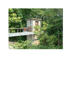
The link below will direct you to a great site with all kinds of weather, many river gauges, all creeks with gages and flood level information covering a large area of Pennsylvania. Specifically, you can hoover the mouse over our two most local gauges.
- Penns Creek Gauge in Penns Creek
- Susquehanna River Gauge in Sunbury
When the map opens you will see numerous colored circles, these circles are the location of water lever gages and are updated continously. If you rest the mouse on a circle it will show the location of the gage. If you click on the circle it will open the gage for that gage location.
These gauges are watched closely as you might expect and help to determine the timing and danger of high waters allowing for early warning to those who could be affected.
The Isle of Que in our Penn Township will begin flooding when the Susquehanna River reaches 20' 8".
At 25' there will four feet of water over the low spots of the road exiting the Isle of Que.
|
Sunbury River Gage
Location - on the right river bank at the borough of Shamokin Dam, on grounds of the Sunbury Generation LP, 1.0 mile downstream from Shamokin Creek, 1.5 mile downstream from the Sunbury Fabridam, and 1.8 mile south of Sunbury.
Established and maintained by the US Geological Survey. Funding for the operation of this station is provided by the PA Dept of Protection, the City of Sunbury Municipal Authority and the US Geological Survey.
The following information provided by the National Weather Service (NWS)
- Action Stage - 20 ft. - river interests encouraged to monitor conditions; Shikellamy State Park closed due to high water.
- Flood Stage - 24 ft. - both banks overflow; areas not protected by flood wall and levee system are affected.
- Moderate Flood Stage - 26 ft. - high water affects a number of homes and businesses in areas not protected by flood wall and levee system.
- Major Flood Stage - 34 ft. - most areas adjacent to river which are not protected by flood wall and levee system are affected by high water. Catastrophic flooding occurs in some of these areas.
|
 |
| Sunbury River Gage |
|
|
|